FREESE-NOTIS
UNITED STATES WEATHER AND CROP COMMENTS
5:00 PM, Sunday, July 26, 2026

FORECAST HIGHLIGHTS
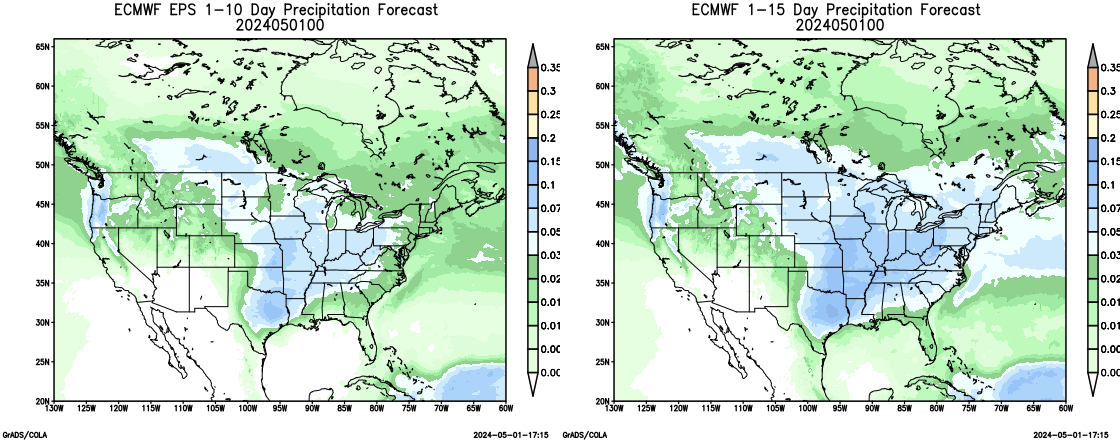
MIDWEST - For the 1-5 day outlook July 26-July 31, corn belt temperatures will average near 82.8 F which is 6.4F from normal. Rainfall will average 0.48". Approximately 73% of the area will receive a 0.25" or more. This compares to the earlier estimate today of 73%. For the 6-10 day outlook, July 31-August 4, the western corn belt temperatures will be ABOVE NORMAL. Rainfall will be BELOW NORMAL. Eastern corn belt temperatures will be ABOVE NORMAL. Rainfall will be NORMAL.
NORTHEAST - For the 1-5 day outlook July 26-July 31, megalopolis area temperatures will average near 74.0 F which is -3.5 F from normal. Rainfall will average 2.19". Approximately 100% of the area will receive a 0.25" or more. This compares to the earlier estimate today of 100%.For the 6-10 day outlook, July 31-August 4, The Megalopolis temperatures will be ABOVE NORMAL. Rainfall will be ABOVE NORMAL.
DELTA/SOUTHEAST - For the 1-5 day outlook July 26-July 31, delta area temperatures will average near 87.3 F which is 5.0 F from normal. Rainfall will average 0.04". Approximately 0% of the area will receive a 0.25" or more. This compares to the earlier estimate today of 0%.For the 6-10 day outlook, July 31-August 4, the Delta region temperatures will be ABOVE NORMAL. Rainfall will be ABOVE NORMAL. The southeast region temperatures will be N normal. Rainfall will be ABOVE NORMAL.
NORTHERN 1/2 PLAINS - For the 1-5 day outlook July 26-July 31, spring wheat temperatures will average near 86.0 F which is 14.1 F from normal. Rainfall will average 0.66". Approximately 84% of the area will receive a 0.25" or more. This compares to the earlier estimate today of 84%.For the 6-10 day outlook, July 31-August 4, the spring wheat temperatures will be ABOVE NORMAL. Rainfall will be BELOW NORMAL.
SOUTHERN 1/2 PLAINS - For the 1-5 day outlook July 26-July 31, winter wheat temperatures will average near 91.7 F which is 12.2 F from normal. Rainfall will average 0.37". Approximately 54% of the area will receive a 0.25" or more.. This compares to the earlier estimate today of 54%.For the 6-10 day outlook, July 31-August 4, the winter wheat temperatures will be ABOVE NORMAL. Rainfall will be BELOW NORMAL.
CROP/LIVESTOCK/ENERGY IMPACTS
MIDWEST - Warmer than normal temperatures will reduce livestock feed needs.
DELTA/SOUTHEAST - Warmer than normal temperatures will reduce livestock feed needs.
NORTHERN 1/2 PLAINS - Colder than normal temperatures will increase livestock feed needs.
SOUTHERN 1/2 PLAINS - Warmer than normal temperatures will reduce livestock feed needs.
PAST WEATHER/SHORT-RANGE FORECAST

MIDWESTERN U.S. (NE to OH and central MN to southern IL)
Yesterday's temperatures across the western corn belt averaged 69.0 F about 5.8 F from normal. Rainfall averaged 0.07". Approximately 4% of the area received a 0.25" or more. Yesterday's temperatures across the eastern corn belt averaged 71.5 F about 7.8 F from normal. Rainfall averaged 0.01". Approximately 0% of the area will received a 0.25" or more.
For the 1-5 day outlook July 26-July 31, corn belt temperatures will average near 82.8 F which is 6.4F from normal. Rainfall will average 0.48". Approximately 73% of the area will receive a 0.25" or more. This compares to the earlier estimate today of 73%.
 SOUTHEASTERN U.S. (Delta east to Carolinas)
For the 1-5 day outlook July 26-July 31, delta area temperatures will average near 87.3 F which is 5.0 F from normal. Rainfall will average 0.04". Approximately 0% of the area will receive a 0.25" or more. This compares to the earlier estimate today of 0%.
For the 6-10 day outlook, July 31-August 4, the Delta region temperatures will be ABOVE NORMAL. Rainfall will be ABOVE NORMAL. The southeast region temperatures will be N normal. Rainfall will be ABOVE NORMAL.
NORTHERN PLAINS (ND to northern NE, eastern MT, eastern WY, northwest MN)
Yesterday's temperatures across the spring wheat belt averaged 57.8 F about 1.5 F from normal. Rainfall averaged 0.12". Approximately 11% of the area received a 0.25" or more.
For the 1-5 day outlook July 26-July 31, spring wheat temperatures will average near 86.0 F which is 14.1 F from normal. Rainfall will average 0.66". Approximately 84% of the area will receive a 0.25" or more. This compares to the earlier estimate today of 84%.
SOUTHERN PLAINS (southern NE to northern TX)
Yesterday's temperatures across the winter wheat belt averaged 72.3 F about 7.3 F from normal. Rainfall averaged 0.04". Approximately 7% of the area received a 0.25" or more.
For the 1-5 day outlook July 26-July 31, winter wheat temperatures will average near 91.7 F which is 12.2 F from normal. Rainfall will average 0.37". Approximately 54% of the area will receive a 0.25" or more.. This compares to the earlier estimate today of 54%.
NORTHEASTERN U.S. MEGALOPOLIS
For the 1-5 day outlook July 26-July 31, megalopolis area temperatures will average near 74.0 F which is -3.5 F from normal. Rainfall will average 2.19". Approximately 100% of the area will receive a 0.25" or more. This compares to the earlier estimate today of 100%.
For the 6-10 day outlook, July 31-August 4, The Megalopolis temperatures will be ABOVE NORMAL. Rainfall will be ABOVE NORMAL.
EXTENDED OUTLOOK & GENERAL OVERVIEW OF U.S. PATTERN
For the 6-10 day outlook, July 31-August 4, the western corn belt temperatures will be ABOVE NORMAL. Rainfall will be BELOW NORMAL. Eastern corn belt temperatures will be ABOVE NORMAL. Rainfall will be NORMAL.

 
Copyright 2024
WAYNE ELLIS/METEOROLOGIST
Freese - Notis Weather
Des Moines, IA 50312
United States of America
Tel (515) 770-3598
E-mail
hfreese@weather.net
IM: weathertrader89
Twitter: @freesenotiswx
Web Page Design Revised last - June 14, 2023 |