FREESE-NOTIS
EVENING WEATHER UPDATE
5:00 PM, Thursday, July 16, 2026


MIDWESTERN U.S.
5:00 PM CDT, Thu Jul 16, 2026
�MIDWEST U.S.� - 1
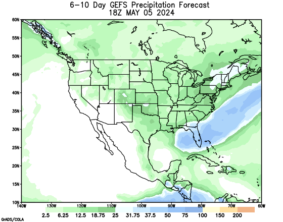
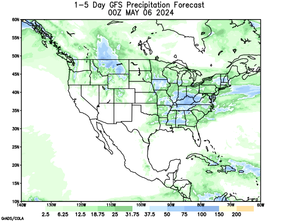
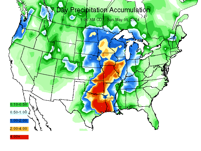
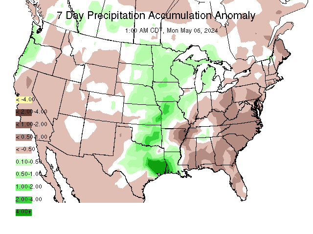
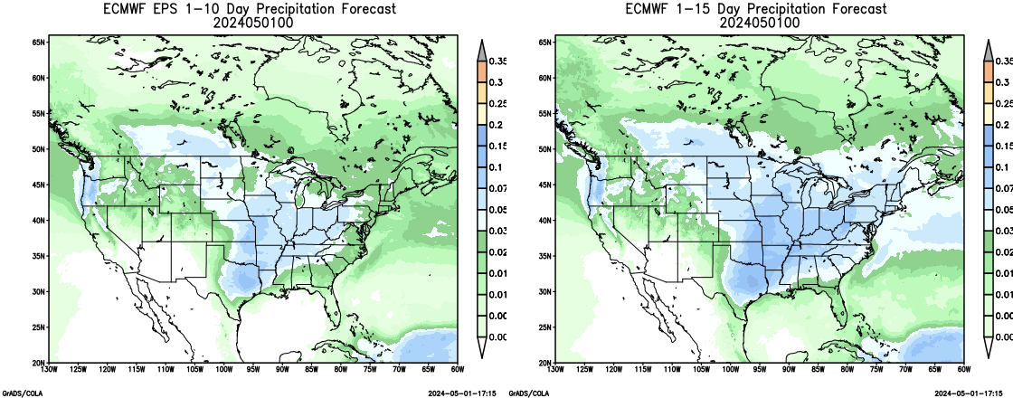
For the 1-5 day outlook July 16-July 21, corn belt temperatures will average near 80.5 F which is 3.9F from normal. Rainfall will average 0.36". Approximately 56% of the area will receive a 0.25" or more. This compares to the earlier estimate today of 56%.
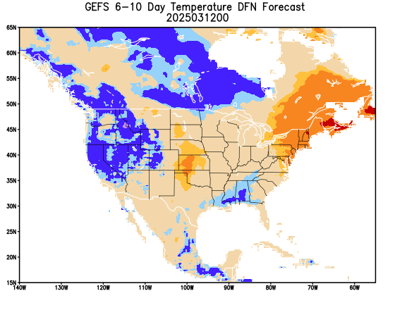
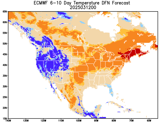
For the 6-10 day outlook, July 21-July 25, the western corn belt temperatures will be normal. Rainfall will be normal. Eastern corn belt temperatures will be Below normal. Rainfall will be normal.
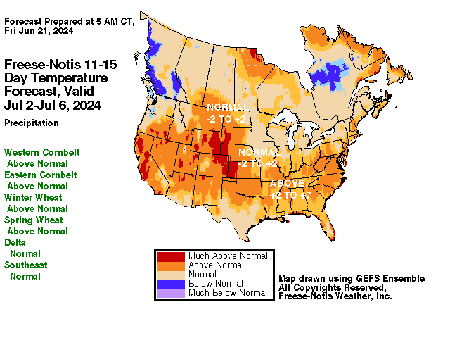
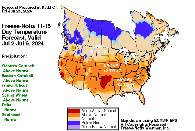
For the 11-15 day outlook July 26-July 30, the western corn belt temperatures will be Above normal. Rainfall will be normal. Eastern corn belt temperatures will be normal. Rainfall will be normal.
SOUTHEASTERN U.S.
For the 1-5 day outlook July 16-July 21, delta area temperatures will average near 84.4 F which is 2.1 F from normal. Rainfall will average 0.19". Approximately 25% of the area will receive a 0.25" or more. This compares to the earlier estimate today of 25%.
For the 6-10 day outlook, July 21-July 25, the Delta region temperatures will be Above normal. Rainfall will be normal. The southeast region temperatures will be Above normal. Rainfall will be Above normal.
For the 11-15 day outlook July 26-July 30, the Delta temperatures will be Above normal. Rainfall will be normal. The southeast region temperatures will be Above normal. Rainfall will be Above normal.
PLAINS
For the 1-5 day outlook July 16-July 21, winter wheat temperatures will average near 84.5 F which is 4.8 F from normal. Rainfall will average 0.26". Approximately 26% of the area will receive a 0.25" or more.. This compares to the earlier estimate today of 26%.
For the 6-10 day outlook, July 21-July 25, the winter wheat temperatures will be Above normal. Rainfall will be normal.
For the 11-15 day outlook July 26-July 30, the winter wheat temperatures will be Above normal. Rainfall will be normal.
NORTHERN PLAINS
For the 1-5 day outlook July 16-July 21, spring wheat temperatures will average near 81.1 F which is 8.7 F from normal. Rainfall will average 0.07". Approximately 0% of the area will receive a 0.25" or more. This compares to the earlier estimate today of 0%.
For the 6-10 day outlook, July 21-July 25, the spring wheat temperatures will be Above normal. Rainfall will be Above normal.
For the 11-15 day outlook July 26-July 30, the spring wheat temperatures will be Above normal. Rainfall will be normal.
NORTHEAST
For the 1-5 day outlook July 16-July 21, megalopolis area temperatures will average near 78.8 F which is 1.1 F from normal. Rainfall will average 0.48". Approximately 75% of the area will receive a 0.25" or more. This compares to the earlier estimate today of 75%.
For the 6-10 day outlook, July 21-July 25, The Megalopolis temperatures will be Below normal. Rainfall will be Above normal.
For the 11-15 day outlook July 26-July 30, The Megalopolis temperatures will be normal. Rainfall will be Above normal.
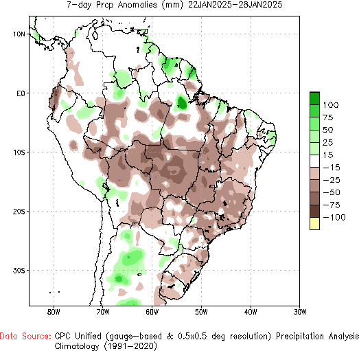
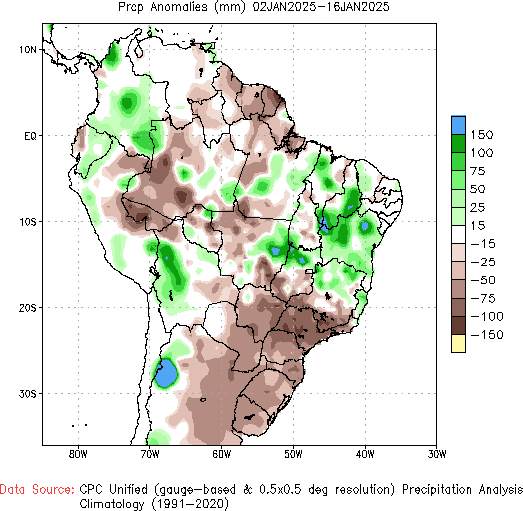
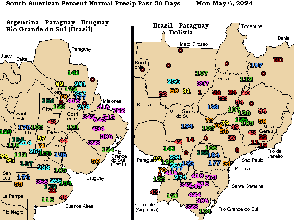
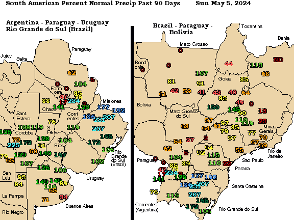
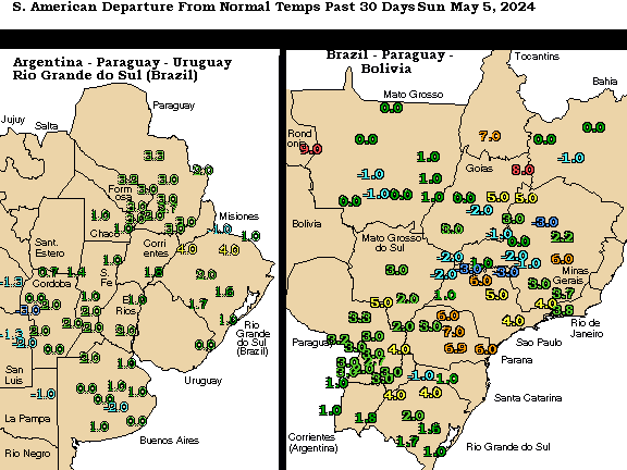
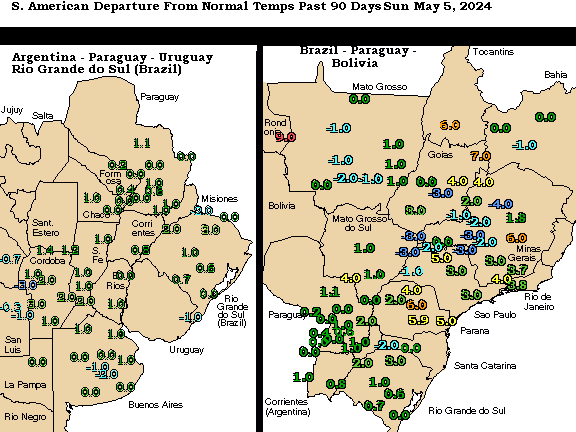
SOUTH AMERICAN TEMPERATURE AND PRECIPITATION MAPS
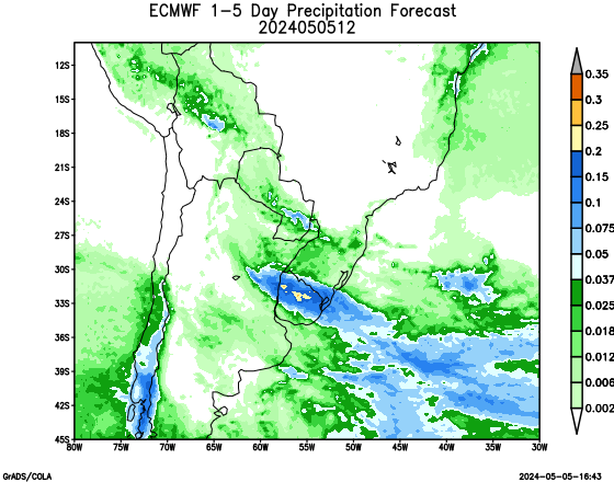
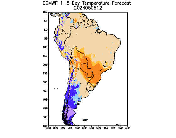
For the 1-5 day outlook July 16-July 21, Brazil Corn area temperatures will average near 72.4 F which is 6.5 from normal. Rainfall will average 0.35. Approximately 10% of the area will receive a 0.25" or more. This compares to the earlier estimate today of %.
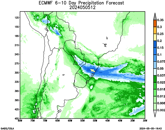
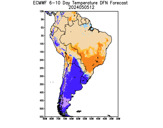
For the 6-10 day outlook July 22 -July 26, Brazil Corn area temperatures will average near 75.2 F which is 9.0 from normal. Rainfall will average 0.32". Approximately 18% of the area will receive a 0.25" or more.
ARGENTINA SOYBEANS


Copyright 2016
Richard Garuckas/Meteorologist
Freese - Notis Weather
Des Moines, IA 50312
Tel (515) 323-6016
E-mail hfreese@weather.net
Twitter @freesenotiswx
|